In late December 2025, North Queensland floods experienced one of its most intense wet-season flood events in recent years. Continuous heavy rainfall over several days pushed rivers, creeks, and drainage systems beyond their limits, leading to widespread flooding across coastal towns, inland communities, and agricultural regions. The rain did not arrive as a single storm but fell persistently, allowing water levels to rise steadily until overflow became unavoidable.
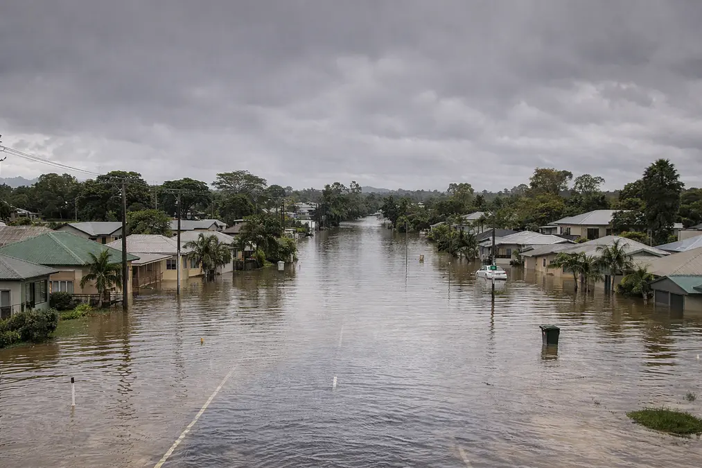
As rainfall continued, major river catchments began responding rapidly. Water spread across floodplains, low-lying roads were submerged, and several transport routes were cut off. In many areas, access to towns became difficult as highways and local roads were overtaken by floodwaters. Emergency services issued flood warnings and advised residents in vulnerable locations to remain alert, as water levels were still rising even after rainfall eased in some areas.
Urban areas faced significant pressure as stormwater systems struggled to cope with prolonged rainfall. Water pooled in residential zones, commercial areas, and industrial estates, disrupting daily life and local services. In rural regions, vast stretches of farmland were inundated, temporarily halting agricultural activity. Livestock had to be moved to higher ground, and crop losses became a growing concern for farmers already dealing with unpredictable seasonal patterns.
The flooding also had serious environmental consequences. Large volumes of freshwater flowed into river systems and eventually toward coastal waters, carrying sediment, nutrients, and debris. This sudden change in water composition affected aquatic ecosystems, reducing water quality and placing stress on fish and other wildlife. Terrestrial animals were forced to move away from flooded habitats, increasing the likelihood of human–wildlife encounters in nearby safe zones.
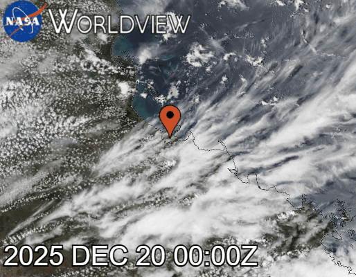
Satellite imagery from NASA Worldview captured on 20 December 2025 showed dense, elongated cloud bands stretching from the Coral Sea onto the Queensland coast. These clouds were a clear sign of sustained moisture transport and weak steering winds, conditions that allow rain to fall repeatedly over the same areas rather than passing through quickly. Communities across North Queensland experienced prolonged disruption rather than short-term damage.
Power interruptions, supply delays, and isolation of smaller towns highlighted how vulnerable remote regions can be during extended flood events. Even after peak water levels passed, recovery was slow as saturated ground delayed drainage and cleanup efforts.
This flood event once again demonstrated how North Queensland’s wet season can shift rapidly from beneficial rainfall to destructive flooding. While flooding is a natural part of the region’s climate, the increasing intensity and duration of such events raise concerns about future resilience. Infrastructure, ecosystems, and communities are being tested more frequently, making long-term planning and flood preparedness more important than ever.
The North Queensland floods of late 2025 were not just about water on roads or rivers breaking their banks. They reflected a broader environmental challenge, where changing weather patterns, land use, and climate pressures combine to increase the scale of impact. Understanding what happened on the ground is essential for preparing for what may come in future wet seasons.