Understanding the scale of what struck Wye River Flooding requires understanding the speed at which it unfolded. This was not a flood that built gradually over days as a swollen river crept toward its banks. It was a flash flood — one of the most dangerous natural hazard events precisely because of how little warning it provides.
166mm of rain was recorded in the Mt Cowley area since 9am — and the event struck in the early afternoon. By mid-afternoon, roads and bridges had been flooded including the Great Ocean Road itself, local caravan parks had been impacted, and there was a risk of landslips and landslides.
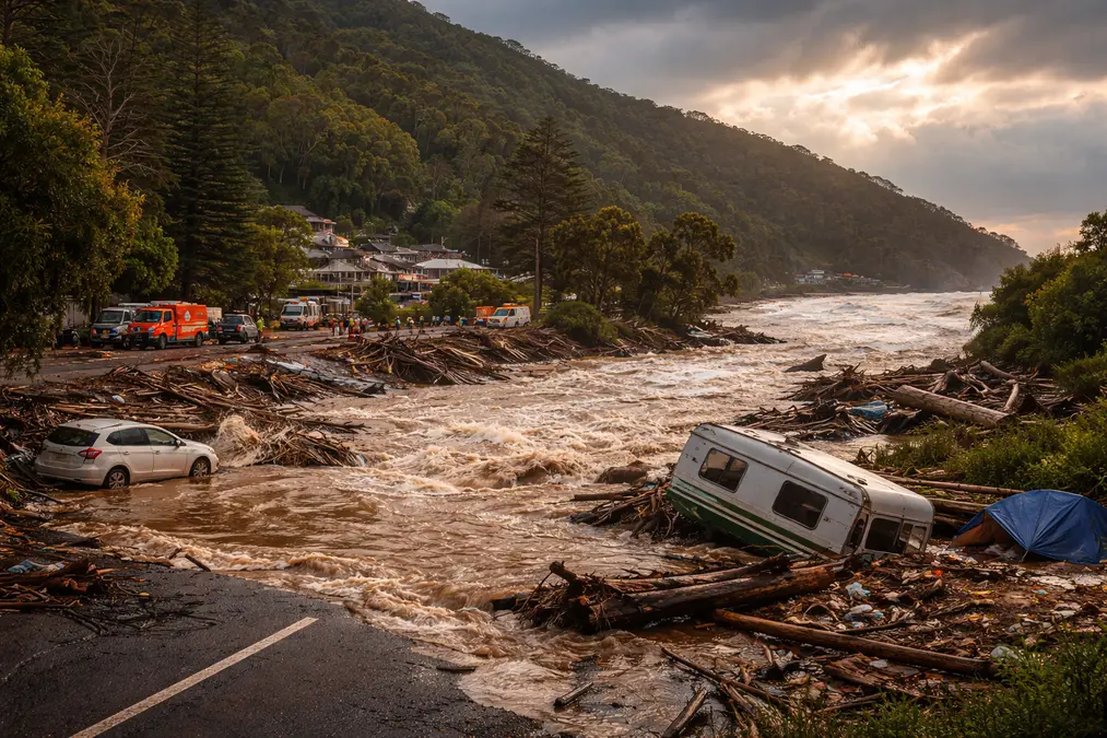
The raging torrents hit Lorne, Wye River, Separation Creek and Cumberland River on Thursday afternoon, sweeping several cars out to sea at Wye River. Sparked by huge downpours, the waters also swallowed riverside campgrounds, forcing panicked campers to run for their safety. Numerous people were rescued after flooding hit in the early afternoon, including a man stranded on a roof at Cumberland River who was winched to safety by police. Several people sheltered on Wye River’s general store roof, cars were left submerged under bridges and floodwaters trapped some holidaymakers in their caravans.
Emergency services carried out multiple rescue operations as fast-rising water tore through campgrounds and cut off sections of the coastal highway. About 400 people were forced from their accommodation at the height of the deluge, with around 60 needing to be housed overnight in the relief centres.
On Thursday 22nd January 2026, Great Ocean Road was closed in both directions between Lorne and Skenes Creek from 6.30am so a helicopter could retrieve the stranded cars. A Black Hawk helicopter and marine salvage crew was called in to remove the cars that had come to rest on rocks, on the beach and out in the sea.
The Albanese and Allan Governments activated disaster assistance for Surf Coast and Colac Otways shires. More than 200 people accessed the relief centre in Lorne in the first two hours alone.
Remarkably — and this is a testament to both emergency services and a degree of fortune — there were no confirmed fatalities directly from the flooding. But the margin was razor-thin. Multiple rescues, a man winched from a rooftop, families separated by floodwater, and at least one survivor who described running for their life with seconds to spare.
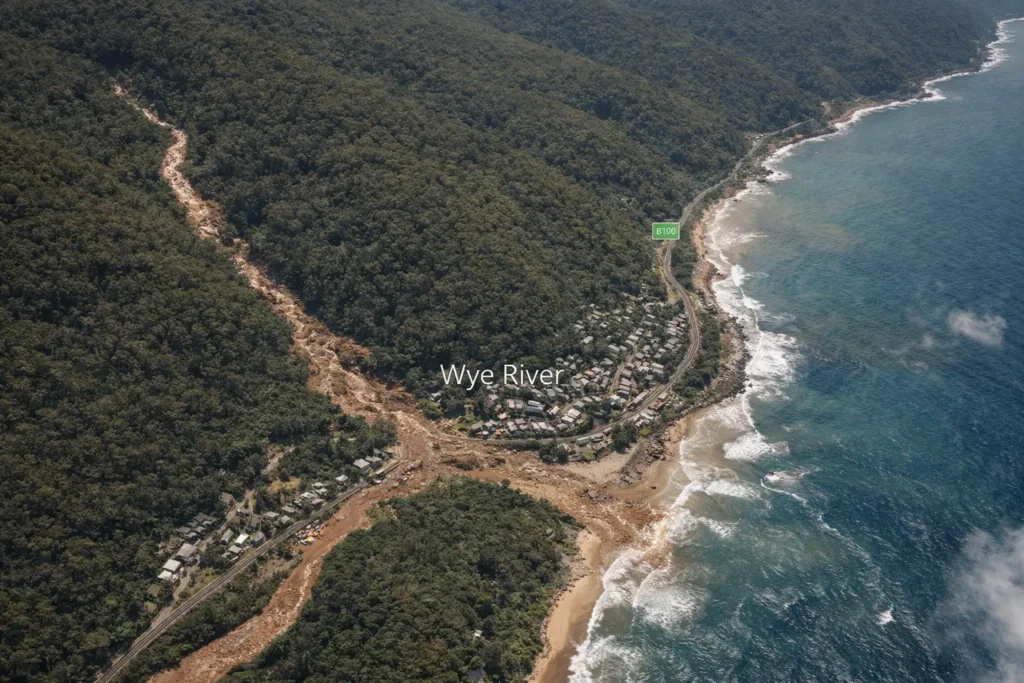
Why Wye River: The Geography That Makes This Location So Dangerous
The question many people asked in the aftermath was a reasonable one: why here? Why Wye River, of all places?
The answer lies in geography — and it is geography that will continue to make this stretch of coastline vulnerable regardless of what emergency management improvements are made.
Wye River features very small and steep catchments draining the southern slopes of the Otways — a forested mountain region in Victoria. These catchments respond very quickly to thunderstorms; it doesn’t take long for rainfall to produce runoff from all parts of the catchment.
This is what hydrologists call a “flashy” catchment. When rain falls on the steep forested slopes of the Otways, there is very little flat ground to slow it, very little storage capacity in the soil to absorb it, and a very direct path downhill to the coast. Water that falls on those hillsides reaches the river within minutes, not hours.
In a catchment like that, flash flooding can happen unbelievably quickly — things can go within minutes from OK to really dangerous.
This physical reality creates a warning problem that has no easy solution. Flash floods are more difficult to predict than slower rising riverine floods. The most intense part of the thunderstorm was only a tiny percentage of the whole area of forecast rainfall — that makes things really difficult to predict.
The location compounds the vulnerability. The campgrounds in such areas are typically on nice flat grassy areas next to the river bank — you can see why people camp and holiday there. But when floods arrive, that’s the worst place to be.
Large populations of tourists unfamiliar with local hazards and emergency arrangements are particularly vulnerable, and caravans and tents can easily be washed away.
This is the tragic geometry of holiday flooding: the places that look most appealing to visitors — flat, sheltered, riverside — are precisely the places where flash floods arrive fastest and with the least warning.
The Five Weather Drivers That Collided Over Victoria
The January 15 event was not simply a heavy rainstorm. The extraordinary storm cell over the Great Ocean Road was powered by a rare collusion of five weather drivers. Extreme thunderstorms with heavy rainfall are often seen in tropical Queensland, but are rare in colder Victoria.
The first driver was ex-Tropical Cyclone Koji. It crossed the Queensland coast on January 11 near Bowen, bringing strong winds and heavy rainfall — and the moisture-laden air it carried eventually intersected with Victorian weather systems in ways that amplified the rainfall intensity dramatically.
Four additional atmospheric drivers combined with the cyclone remnants to produce rainfall intensity that the Bureau of Meteorology described as record-breaking for the region — more than 180mm in under five hours in an area where the steep terrain ensured that virtually all of it became runoff within minutes.
The rarity of this specific combination matters — but not in the way that might seem comforting. Rare does not mean unrepeatable. And climate science tells us with increasing confidence that the conditions that make extreme precipitation events possible are becoming more common.
Senior meteorologist Angus Hines at the Bureau of Meteorology said: “As the world warms, extreme weather events tend to get more extreme.”
Due to global warming over the last 30 years, there is clear evidence the intensity of such thunderstorm events have increased by 15 to 20 percent.
The collision of five weather drivers over Victoria on January 15 was unusual. The physical conditions that allowed those drivers to produce record-breaking rainfall — a warmer, more moisture-laden atmosphere — are becoming less unusual every year.
From Fire to Flood: A Community That Has Faced Too Much
The Wye River flooding of January 2026 did not arrive in an emotional vacuum.
The flash flooding came just a few weeks after Wye River commemorated 10 years since the bushfire that destroyed 116 houses.
That anniversary — ten years since Christmas Day 2015, when fire swept through the community and left over 100 families without homes — was still fresh in the community’s memory when the floodwaters arrived. The same streets that had been rebuilt from fire ash now had cars floating through them. The same community that had spent a decade restoring what was lost was suddenly watching the river take more.
This is the compound disaster pattern that climate scientists have been warning about for years — and that affected communities are now living through in real time. Wye River is not an outlier. It is a preview.
The psychological weight of repeated disaster — rebuilding after fire, then facing flood, with the knowledge that neither the fire risk nor the flood risk has diminished — creates a form of community trauma that emergency management frameworks are not well designed to address. Material damage can be assessed and compensated. The erosion of confidence in place — the creeping sense that the land you love has become unpredictable and dangerous — is harder to quantify and much harder to repair.
Victorian Minister for Emergency Services Vicki Ward said: “This was a fast-moving and dangerous weather event that forced people to leave their homes, holiday accommodation and businesses.”
The Wildlife Dimension: What Floods Do to Ecosystems Silently
The human drama of the Wye River flooding dominated media coverage. But the ecological consequences — quieter, slower to become visible, and in some ways longer-lasting — deserve equal attention.
The Otway Ranges that drain into Wye River are part of one of Victoria’s most biodiverse landscapes. The cool temperate rainforests of the Otways support populations of koalas, echidnas, platypus, powerful owls, and dozens of species of native birds and reptiles that live in or near the riparian zones — the strips of habitat along riverbanks and streams — that flash floods strike hardest.
Animals caught in a flash flood face a category of challenge different from slow-rise riverine flooding. There is no gradual retreat to higher ground. The water arrives faster than most terrestrial animals can respond. Ground-nesting birds — superb lyrebirds, Australian brush turkeys — lose nests that cannot be replaced mid-season. Small mammals sheltering in hollow logs at ground level are trapped. Platypus burrows in riverbanks are destroyed by erosion.
Floodwater also carries pollutants: fuel washed from submerged vehicles, waste from overwhelmed septic systems, debris from campsites. This enters creek systems and eventually the ocean, affecting the rocky reef ecosystems along the Great Ocean Road coast that support cold-water marine life including seals, fur seals, and diverse fish populations.
The ecological recovery timeline is long. Riverbank vegetation stripped by the flood takes seasons to regrow. Soil structure damaged by high-velocity water takes years to stabilize. And with the frequency of extreme events increasing, that recovery time is being compressed — each event striking before the previous one’s damage has fully healed.
Why Warning Systems Are Failing Flash Flood Victims
One of the most important and uncomfortable truths about the Wye River flooding is that the warnings were technically issued — and people still got caught.
The State Emergency Service issued an emergency flash flood warning for Wye River, Kennett River, Cumberland River, Lorne and surrounds, describing very dangerous conditions being caused by a severe thunderstorm and flash flooding.
Yet 400 people were displaced. A man was rescued from a rooftop. Cars ended up in the sea.
The gap between warning issued and warning acted upon is a research problem that Australian emergency management experts have been studying for years. Research has found that key terminology employed in Bureau flash flooding severe weather warnings is often misunderstood. Communities often may not follow warning instructions, relying on local knowledge and information networks to make protective decisions for themselves and loved ones.
This finding is not a criticism of the people who stayed. It is a recognition of something psychologically real: it can be difficult to think about risk when you’re on holidays; it’s easy to switch off and just think you’ll wait the rain out. Even someone who studies floods for decades can imagine being caught out in holiday mode and being slow to respond.
The challenge is structural. Flash floods in catchments like Wye River develop faster than warnings can realistically be issued, distributed, understood, and acted upon by a population that is largely transient, unfamiliar with local geography, and in “holiday mode.” There is little or no opportunity to provide effective flood warning in these catchments.
This does not mean warnings are useless. It means the warning system — as currently designed — is insufficient for the geography and the population it serves. Improvement requires investment in more granular, location-specific alerting, better communication of what “flash flood emergency” actually means in practical terms, and closer integration between caravan park and campground operators and emergency services.
Climate Change: The Multiplier Behind the Event
The January 15 event had a specific meteorological cause — five converging weather systems, triggered in part by a weakened tropical cyclone. But the intensity of what those systems produced was amplified by a background condition that affects every extreme weather event on Earth today: a warmer, more moisture-laden atmosphere.
The physics is straightforward. For every degree Celsius of atmospheric warming, the air can hold approximately 7 percent more water vapor. More water vapor means heavier rainfall when precipitation occurs. The rainfall totals recorded at Wye River and surrounding areas on January 15 — 180mm in under five hours — were in the range of what is possible in a warmer climate, in a region that historically experienced such intensities only in tropical Queensland.
These one-in-hundred chance floods will occur somewhere every year, and with climate change these kinds of events will become more intense and more frequent. Due to global warming over the last 30 years, there is clear evidence the intensity of such thunderstorm events have increased by 15 to 20 percent.
The implication for planning is direct: the flood risk maps, engineering standards, and land-use approvals that govern development along rivers like Wye River were calibrated on historical data. That historical data increasingly underestimates future risk.
Caravan parks approved and designed using flood frequency data from 30 years ago are now exposed to flood events that were not in the statistical distribution when they were built. The gap between historical risk assumptions and current reality is widening every decade — and without systematic revision of flood planning standards to incorporate climate projections, it will continue to widen.
What Needs to Change: Practical Recommendations
The Wye River flooding of January 2026 is not simply a disaster to recover from. It is a dataset from which specific, actionable lessons can be drawn.
For emergency warning systems: Identifying and filling warning system gaps for high-risk areas is essential, including the provision of community engagement campaigns regarding flash flood risks. Flash floods can be deadly, and communities need to understand what to do.
For campground and caravan park management: Ensuring vulnerable facilities have emergency plans and are connected to warning systems is non-negotiable. Campground operators in flash-flood-prone locations need direct, real-time links to Bureau of Meteorology warnings and pre-established protocols for rapid evacuation that do not depend on guests reading their phones.
For land use planning: The placement of high-capacity campgrounds and caravan parks in flash-flood catchments needs systematic review. The flat, riverside locations that make these sites appealing are precisely the locations that flood first and fastest. Zoning frameworks need to incorporate current and projected flood risk — not historical averages.
For visitors: Simple, direct guidance — not technical weather language — about what to do when a thunderstorm warning is issued while camping near a river in a steep coastal catchment: leave for higher ground before the rain arrives, not after it starts. This one behavioral change, if widely adopted, would dramatically reduce casualties from events like January 15.
Frequently Asked Questions
Q: What exactly happened at Wye River on January 15, 2026?
A flash flood triggered by record-breaking rainfall — more than 180mm in under five hours — swept through Wye River, Lorne, Cumberland River, and Kennett River on January 15, 2026. Cars were swept into the sea, campgrounds were inundated, approximately 400 people were displaced, and multiple rescues were carried out including a man winched from a rooftop by police helicopter. The Great Ocean Road was closed for days and disaster assistance was activated by both state and federal governments.
Q: Was this a one-in-a-lifetime event, or will it happen again?
Flash floods of this type will occur again — in this area and in similar coastal catchments across Australia. The specific combination of five weather drivers that triggered the January 15 event was unusual. But the broader climate conditions that amplify rainfall intensity are becoming less unusual. Research shows thunderstorm intensity has increased by 15 to 20 percent over the last 30 years due to global warming. One-in-hundred-year floods now occur more frequently than their name suggests.
Q: Why were people caught by the flood despite warnings being issued?
Flash floods in steep coastal catchments like Wye River develop faster than warnings can realistically be distributed and acted upon — especially by a transient holiday population unfamiliar with local hazards. Research consistently finds that flash flood warning terminology is often misunderstood, and that people in holiday mode are less likely to respond quickly to weather alerts. Structural improvements to warning systems and campground emergency protocols are needed.
Q: What is the connection between the 2015 Wye River bushfire and the 2026 flood?
They are linked through the same landscape vulnerability that climate change is intensifying. The 2015 Christmas Day bushfire destroyed 116 homes. The January 2026 flood struck the same community just weeks after the 10-year commemoration of that fire. Both events reflect the increasing frequency of extreme weather in the region. Burned slopes can also increase runoff during heavy rain — creating a physical connection between fire events and subsequent flood risk.
Q: What can people do to stay safe when camping near rivers in Australia?
The most important action: treat any severe thunderstorm warning as a signal to move to higher ground immediately — before rain begins, not after. Do not wait to see how serious the weather becomes. Flat, riverside campsites that look sheltered are the first areas to flood and the last to drain. Check Bureau of Meteorology warnings before and during your stay. Know the location of the nearest high ground. Register your presence with campground managers who can relay emergency alerts.