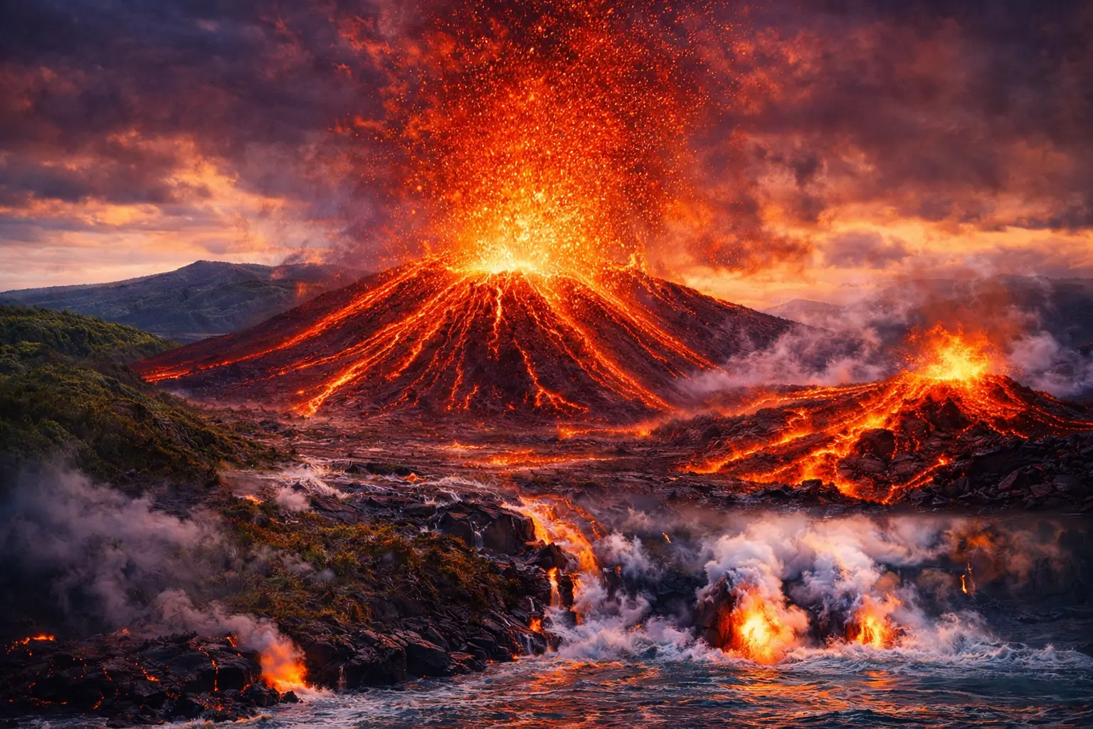
It was not a fire. It was not a sunrise. It was Kilauea Volcano— Earth’s most continuously active volcano — announcing yet another eruption from its summit crater. Within hours, lava fountains were shooting 25 meters into the air. A lava lake that had partially drained was refilling in real time, glowing like a window into the planet’s molten interior.
Scientists had seen this before. They had predicted it. Sensors, satellites, and seismometers had been watching the subtle signs for days — ground swelling, small earthquakes clustering beneath the summit, sulfur dioxide levels rising.
And yet, standing at the crater rim and watching the Earth open itself up, even the most experienced volcanologist will tell you the same thing: nothing fully prepares you for it.
Kilauea is not simply a volcano. It is a living demonstration of the forces that built this planet — and that continue reshaping it, slowly and sometimes violently, beneath our feet. This is its story.
Where Is Kilauea and Why Does It Exist There?
Kilauea sits on the southeastern flank of the Big Island of Hawaii, nestled within Hawaii Volcanoes National Park — a UNESCO World Heritage Site that draws over two million visitors annually. It occupies the lower eastern slope of its much larger neighbor, Mauna Loa, though Kilauea has its own independent plumbing system and magma supply.
But the more fundamental question is not where Kilauea is — it is why it exists at all.
Hawaii is in the middle of the Pacific Ocean, thousands of kilometers from the nearest tectonic plate boundary. Most volcanoes on Earth form at these boundaries, where plates collide or pull apart. Hawaii breaks that rule entirely.
The Hawaiian Islands exist because of a mantle hotspot — a column of unusually hot material rising from deep within the Earth’s mantle, possibly from the boundary between the mantle and the core itself. This hotspot has burned through the Pacific Plate like a blowtorch through sheet metal, creating a chain of volcanic islands stretching 2,400 kilometers across the Pacific.
As the Pacific Plate moves northwestward over the stationary hotspot — at roughly 7 centimeters per year — it carries older islands away from the heat source. Those islands gradually erode and sink. New ones form above the hotspot.
The Big Island of Hawaii is the youngest island in the chain. Kilauea sits directly above the hotspot’s current position. This is why it erupts so frequently, so persistently, and so productively — it is sitting on the most direct pipeline to the Earth’s interior that exists anywhere on the planet’s surface.
What Kind of Volcano Is Kilauea — And Why That Matters
Kilauea is a shield volcano — a classification that shapes everything about how it behaves, how dangerous it is, and why it looks so different from the cone-shaped volcanoes most people picture.
Shield volcanoes are built by thousands of thin lava flows accumulating over millions of years. Because Hawaiian lava — called basaltic lava — is extremely hot and low in silica, it flows easily rather than piling up steeply. The result is a broad, gently sloping structure that resembles a warrior’s shield laid flat on the ground.
Kilauea’s summit rises only about 1,247 meters above sea level — modest compared to composite volcanoes like Mount Fuji or Mount St. Helens. But its footprint is vast, and what it lacks in height it more than compensates for in volume and activity.
This matters enormously for safety. Shield volcanoes like Kilauea generally do not produce the catastrophic explosive eruptions that made Pompeii and Mount St. Helens infamous. Their lava is too fluid, their gas content too low, to build up the pressure that causes those devastating blasts. Instead, Kilauea typically erupts through fissures and vents, producing lava flows that move at human-walkable speeds — dangerous, destructive, but rarely instantly lethal.
The exception to this rule — and there is always an exception with volcanoes — comes when lava interacts with water.
The Summit and the Rift Zones: Kilauea’s Anatomy
To understand Kilauea’s behavior, you need to understand its three main structural components.
Halema’uma’u Crater: The Heart of Kilauea
At Kilauea’s summit sits Halema’uma’u Crater — a pit crater roughly one kilometer wide that has served as the volcano’s most dramatic surface expression for centuries. In Hawaiian tradition, Halema’uma’u is the home of Pele, the goddess of volcanoes and fire, making it one of the most sacred sites in Native Hawaiian culture.
Scientifically, Halema’uma’u is where Kilauea’s magma reservoir comes closest to the surface. When magma levels rise, the crater floor rises and lava lakes form. When magma drains toward the rift zones or erupts elsewhere, the crater floor drops, sometimes dramatically.
During the 2018 eruption, the crater floor collapsed by over 500 meters — one of the most dramatic volcanic collapses recorded in modern history.
The East Rift Zone: Where Lava Meets Communities
Extending eastward from the summit is Kilauea’s East Rift Zone — a crack in the Earth’s surface along which magma can travel from the summit reservoir and erupt at lower elevations. The East Rift Zone is where Kilauea’s most destructive modern eruptions have occurred, including the devastating 2018 event that destroyed hundreds of homes in the Leilani Estates neighborhood.
The Southwest Rift Zone
A second rift zone extends to the southwest, though it is less frequently active than the East Rift Zone. Both rift zones represent pathways through which magma escapes when the summit reservoir fills beyond capacity.
Kilauea’s Most Significant Eruptions in History
Pu’u ‘O’o: The 35-Year Eruption (1983–2018)
The numbers are almost incomprehensible.
From January 3, 1983 to April 30, 2018 — 35 years, 3 months, and 27 days — Kilauea erupted continuously from a vent called Pu’u ‘O’o in the East Rift Zone. It became the longest-duration rift zone eruption in the volcano’s recorded history.
During those 35 years, lava flows covered over 130 square kilometers of land. They buried entire communities, including the town of Kalapana in 1990, destroying over 100 homes. They crossed Highway 130 repeatedly, forcing permanent rerouting. They added 2.7 square kilometers of new land to the Big Island by flowing into the ocean and solidifying.
The Pu’u ‘O’o eruption did not end because it ran out of magma. It ended because the magma dramatically redirected in 2018 — with consequences that shocked even experienced volcanologists.
The 2018 Lower East Rift Zone Eruption: When Kilauea Devastated a Community
The 2018 eruption began in early May when magma that had been feeding Pu’u ‘O’o suddenly drained away and re-emerged in the Leilani Estates residential subdivision — a neighborhood of several thousand residents who had chosen to live in one of the world’s most geologically active areas.
What followed over the next four months was one of the most destructive volcanic events in modern American history.
24 fissures opened in residential streets. Lava fountains reached heights of 80 meters. Lava flows moved with enough speed and volume to overtake cars on roads. By the time the eruption ended in September 2018:
- 716 homes had been destroyed
- Over 2,000 residents had been displaced
- More than 35 square kilometers of land had been covered
- The ocean entry created 3.5 square kilometers of new land
Remarkably, despite the scale of destruction, only one person was directly killed by lava — struck by a lava bomb while sitting on a balcony. The relatively low death toll was a direct result of early warning systems, mandatory evacuations, and years of community preparedness.
The 2020–Present Summit Eruptions
After a period of quiet following 2018, Kilauea resumed erupting at its summit in December 2020, creating a new lava lake in Halema’uma’u Crater. Since then, eruptions have continued intermittently, with significant events in 2021, 2022, 2023, and 2024. Each eruption has been closely monitored and has attracted thousands of visitors to Hawaii Volcanoes National Park to witness active lava flows firsthand.
The Dangers Nobody Talks About: Beyond Lava Flows
Most people focus on lava when they think about Kilauea’s dangers. But volcanologists will tell you that lava is often the least immediately deadly hazard. The less visible threats are sometimes more dangerous.
Volcanic Smog (Vog)
When Kilauea erupts, it releases enormous quantities of sulfur dioxide gas. When this gas reacts with sunlight, moisture, and oxygen in the atmosphere, it creates a hazy, acidic smog called vog — volcanic fog.
Vog can travel hundreds of kilometers from Kilauea, affecting air quality across the entire Hawaiian island chain and beyond. For people with respiratory conditions — asthma, COPD, or heart disease — vog can trigger serious health crises. Even healthy individuals experience eye irritation, throat soreness, and breathing difficulty during periods of heavy vog.
During major eruptions, vog has been measured at hazardous levels as far away as Honolulu, over 300 kilometers from the summit.
Laze: When Lava Meets the Ocean
When lava flows enter the ocean, it creates a phenomenon called laze — a condensed mixture of steam, hydrochloric acid, and tiny shards of volcanic glass. This white plume, which looks deceptively like harmless steam from a distance, can cause severe lung damage and chemical burns.
In 2000, two people died after being exposed to laze at a lava ocean entry point in Hawaii. The hazard is not always clearly marked, and its danger is systematically underestimated by visitors.
Lava Tubes and Ground Collapses
Lava does not always flow on the surface. It frequently travels through lava tubes — tunnels formed when the outer surface of a lava flow cools and solidifies while molten lava continues moving inside. When the lava eventually drains, it leaves a hollow tube that can extend for kilometers.
The ground above old lava tubes is often thin and unstable. Collapses — called bench collapses at ocean entries — can happen without warning, dropping land and anyone standing on it into active lava or the ocean.
Pele and the Sacred Relationship Between Kilauea and Native Hawaiians
No article about Kilauea is complete without understanding its cultural dimension — because for Native Hawaiians, this volcano is not simply a geological feature. It is a living entity, a deity, and an ancestor.
Pele — the goddess of fire, lightning, wind, and volcanoes in Hawaiian religion — is believed to reside in Halema’uma’u Crater at Kilauea’s summit. Hawaiian oral tradition describes Pele as the creator of the Hawaiian Islands, traveling from island to island, with Kilauea as her current and permanent home.
For Native Hawaiians, Kilauea’s eruptions are not disasters — they are Pele’s creative and destructive power made visible. Lava flows are sometimes referred to as “Pele’s hair” (thin glass fibers carried by wind from lava fountains) and “Pele’s tears” (small rounded glass droplets). The land created by lava entering the ocean is considered Pele’s gift — new earth, new beginning.
This perspective creates genuine tension when Kilauea threatens infrastructure or requires evacuations. For many Native Hawaiians, the question of whether to fight Pele’s flows — through diversion efforts or other interventions — carries deep spiritual weight that is not always acknowledged in emergency management discussions.
Understanding this cultural context is not optional background information. It is essential to understanding how communities near Kilauea experience, interpret, and respond to volcanic activity.
How Scientists Monitor Kilauea: The World’s Best-Watched Volcano
The Hawaiian Volcano Observatory (HVO), operated by the United States Geological Survey, has been continuously monitoring Kilauea since 1912 — making it one of the longest-running volcano monitoring programs on Earth.
The tools and techniques deployed at Kilauea represent the state of the art in volcanology:
Seismic networks detect the small earthquakes that accompany magma movement, providing the earliest warning of subsurface activity changes.
GPS and tiltmeters measure ground deformation — the swelling and sinking of the volcanic edifice as magma enters or leaves the shallow reservoir. Ground uplift of even a few centimeters can signal an impending eruption.
Gas sensors continuously measure sulfur dioxide emissions. Sudden spikes in SO2 indicate that fresh, gas-rich magma is approaching the surface.
Thermal cameras and webcams provide 24-hour visual monitoring of the summit, rift zones, and active lava flows.
Satellite radar measures ground deformation across the entire volcano at regular intervals, capturing changes that ground-based instruments might miss.
The data from these systems is processed in real time and used to issue public advisories through a color-coded alert system: Green (normal), Yellow (advisory), Orange (watch), Red (warning — eruption imminent or occurring).
This monitoring infrastructure is why the 2018 eruption, despite its unprecedented destructiveness, caused so few direct fatalities. The warnings came days before the worst activity, allowing evacuations to be completed.
What Kilauea Teaches the World
Kilauea’s value to global science extends far beyond Hawaii.
Because it erupts so frequently and accessibly, Kilauea has allowed volcanologists to study processes that are nearly impossible to observe at more explosive or remote volcanoes. Research conducted at Kilauea has directly contributed to:
- Improved understanding of how magma moves through volcanic plumbing systems
- Better models for predicting eruption location and timing at volcanoes worldwide
- Development of monitoring techniques now deployed at dangerous volcanoes in Indonesia, Italy, Iceland, and elsewhere
- Understanding of how volcanic islands form — with direct implications for understanding the geological history of ocean basins globally
Every eruption at Kilauea is simultaneously a potential disaster for nearby communities and an extraordinary scientific opportunity. The challenge — one that Hawaii Volcanoes National Park and HVO manage with considerable skill — is honoring both realities at once.
Frequently Asked Questions
Q: Is Kilauea currently erupting?
Kilauea has been in a state of frequent eruptive activity since 2020, with eruptions occurring at the summit crater intermittently. The Hawaiian Volcano Observatory provides real-time updates. Current alert levels are always posted there before planning any visit to Hawaii Volcanoes National Park.
Q: Can tourists safely visit Kilauea?
Yes, with appropriate precautions. Hawaii Volcanoes National Park is open year-round and offers extraordinary opportunities to see volcanic activity safely. During active eruptions, the park service and HVO establish viewing areas at safe distances. Visitors should always check current conditions before arriving, stay on marked trails, and heed all posted warnings about vog, unstable ground, and laze.
Q: How does Kilauea compare to other active volcanoes in the world?
Kilauea is generally considered the world’s most continuously active volcano by volume of lava produced and duration of activity. Mount Etna in Sicily and Stromboli in Italy are also highly active. Indonesia’s Merapi and Sinabung are more explosively dangerous. What makes Kilauea exceptional is the combination of frequency, scientific accessibility, and the existence of a long-term monitoring program dating back over a century.
Q: Will Kilauea ever stop erupting?
On human timescales, Kilauea will continue erupting for the foreseeable future. The hotspot beneath Hawaii shows no signs of weakening. The Big Island will eventually move far enough from the hotspot to lose its magma supply — but that process takes millions of years. A new volcanic island, Lo’ihi, is already forming underwater southeast of the Big Island, directly above the hotspot, and will eventually emerge from the ocean in roughly 10,000 to 100,000 years.
Q: What should I do if I live near Kilauea and an eruption warning is issued?
Follow instructions from Hawaii County Civil Defense and Hawaii Volcanoes National Park immediately. Know your evacuation zone — the Big Island is divided into numbered lava hazard zones, with Zone 1 being highest risk. Have a go-bag prepared with water, medications, important documents, and supplies for at least 72 hours. Register with local emergency management so authorities know your location. Do not wait to see how serious it becomes before evacuating — lava moves faster than it appears.