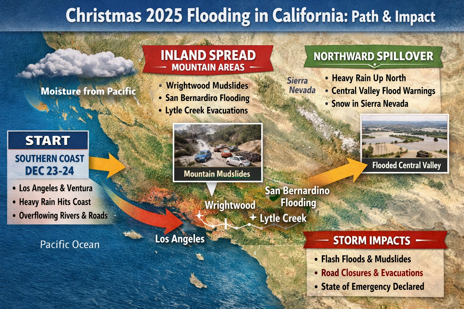
The Christmas week flooding of 2025 marked a significant environmental event in Southern California, revealing the growing sensitivity of semi-arid landscapes to extreme weather systems. Between December 18 and December 24, a prolonged storm sequence delivered unusually high moisture levels to the region, transforming seasonal rainfall into a widespread hydrological disturbance with lasting ecological consequences.
This event was driven by a strong atmospheric moisture corridor originating over the Pacific Ocean, where warm ocean conditions enabled the transport of large volumes of water vapor toward the western coast of North America. As this moisture made landfall over Southern California, repeated cloud bands stalled over coastal and inland zones, resulting in sustained precipitation rather than short-lived rainfall. The persistence of this system was a critical factor in the scale of flooding that followed. Orbital observations captured during this period, including animated visual sequences used in this analysis, illustrate continuous cloud regeneration over the same geographic corridor. These observations confirm that rainfall was not evenly distributed but concentrated along a narrow path that intersected urban basins, river channels, and mountain foothills. Such concentration significantly increased runoff intensity, overwhelming both natural and engineered drainage systems.
From an environmental perspective, the timing of the storm amplified its impact. Southern California’s soils, adapted to long dry intervals, exhibited reduced infiltration capacity after the first phase of rainfall. Once surface layers became saturated, subsequent precipitation rapidly converted into surface runoff. This process accelerated erosion, destabilized slopes, and transported sediment into waterways at rates far exceeding seasonal norms.
Mountainous regions played a decisive role in shaping the flood dynamics. As moist air masses encountered elevated terrain, orographic lifting intensified rainfall along slopes and foothills. Burn-scarred landscapes from previous wildfire seasons proved especially vulnerable. Vegetation loss and altered soil structure in these areas reduced root stabilization, allowing rainwater to mobilize debris, sediment, and organic matter downslope. The result was a series of mudflows and debris flows that extended environmental damage beyond floodplains into upland ecosystems.
River systems and ephemeral streams responded quickly to the excess runoff. Channels that typically remain dry during winter months experienced sudden flow surges, redistributing sediments and altering stream morphology. These rapid changes disrupted aquatic habitats, displaced invertebrate populations, and temporarily degraded water quality through increased turbidity and nutrient loading. Such disturbances can have cascading effects, influencing fish spawning grounds and riparian vegetation recovery well beyond the immediate flood period.
Urban environments further intensified environmental stress. Impermeable surfaces such as roads, rooftops, and paved drainage corridors limited water absorption, increasing flow velocity into nearby rivers and coastal outlets. This rapid transfer of storm water carried pollutants, oils, and debris into natural water bodies, temporarily elevating contamination levels and placing additional strain on coastal ecosystems.
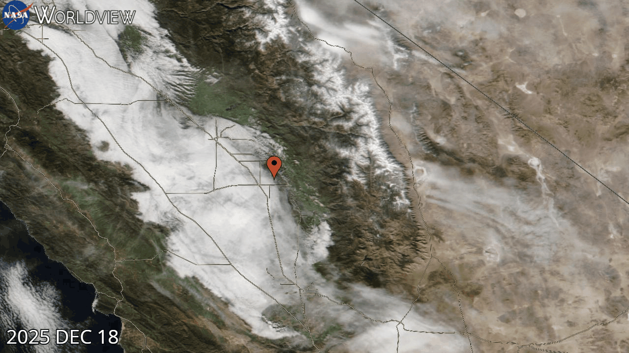
The satellite animation incorporated into this study period provides valuable insight into the temporal evolution of the storm. The visual sequence demonstrates how moisture delivery remained continuous over multiple days, rather than dispersing after a single frontal passage. This persistence explains why flooding expanded progressively from southern coastal zones toward inland valleys and foothill systems. Environmental impacts therefore unfolded in stages, beginning with soil saturation, followed by runoff acceleration, and culminating in widespread habitat disruption.
Vegetation response to the flooding presented a complex picture. While excess water posed immediate risks to plant stability and root systems, especially in erosion-prone zones, it also replenished groundwater reserves and soil moisture profiles depleted by earlier drought conditions. Native plant species adapted to episodic flooding may benefit in the long term, provided that post-flood erosion and sediment deposition do not permanently alter soil composition.
Wildlife interactions with the altered landscape reflected both displacement and adaptation. Flooded lowlands forced terrestrial species toward higher ground, increasing interspecies competition and temporarily compressing habitat ranges. Aquatic species faced sudden changes in flow regime and water chemistry, conditions that require significant physiological adjustment. These stressors highlight the importance of maintaining ecological corridors and floodplain buffers capable of absorbing hydrological extremes.
From a broader environmental science perspective, the Christmas 2025 flooding underscores the increasing variability of precipitation patterns in Mediterranean-climate regions. The combination of prolonged dry periods followed by concentrated rainfall events challenges existing land management frameworks. Flood mitigation strategies designed for gradual seasonal rainfall are less effective under conditions of rapid moisture delivery and persistent atmospheric systems.
The integration of orbital observational data into environmental assessment enhances understanding of such events by providing large-scale, time-resolved context. When combined with ground-based measurements, these observations allow researchers to trace storm evolution, assess landscape response, and evaluate ecosystem vulnerability with greater accuracy. This approach supports more informed planning for watershed management, habitat conservation, and climate resilience.
The Christmas week flooding of 2025 serves as a clear environmental signal rather than an isolated anomaly. It reflects the interaction between atmospheric dynamics, land-use patterns, and ecosystem resilience. As similar events become more frequent, the need for science-driven environmental monitoring and adaptive land management becomes increasingly urgent. Understanding how landscapes respond to sustained moisture inputs is essential for protecting both natural systems and the communities that depend on them.

