On the morning of January 7, 2026, seismologists watching global earthquake monitoring dashboards noticed something unusual.
The map was lighting up.
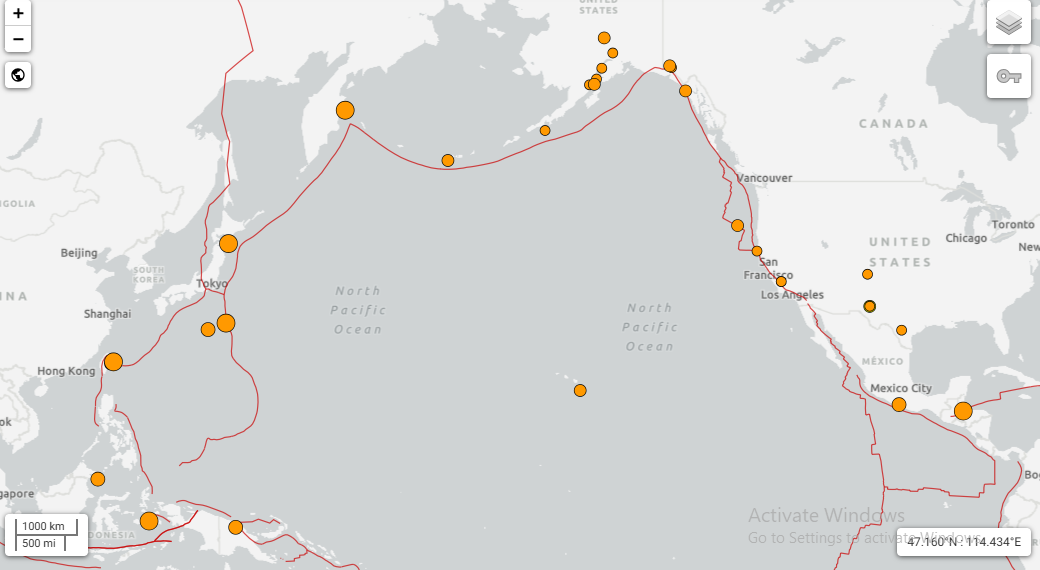
Yellow dots — each representing a recorded seismic event — were clustering along coastlines and ocean boundaries at a rate that was visibly higher than the seasonal average. Japan. Alaska. Mexico. Indonesia. The western United States. Within the first two weeks of January alone, dozens of notable earthquakes had been recorded across multiple continents.
Social media filled with questions. News channels ran segments. And a very human anxiety surfaced in comment sections worldwide: Is something happening to the Earth?
The answer is both reassuring and humbling. What the world witnessed in early January 2026 was not a sign of impending global catastrophe. It was the Earth doing what it has always done — moving, shifting, releasing stress that has built up over years beneath our feet. What made it visible was our ability to measure it, and what made it feel sudden was how little most people understand about the planet they live on.
This article explains exactly what happened, why it happened, and what it means for the future.
What the Data Actually Showed in Early January 2026
Between January 1 and January 25, 2026, global seismic monitoring networks recorded a noticeable increase in earthquake activity, particularly concentrated along coastal zones and ocean boundaries.
The affected regions were not random. They followed a precise geographic pattern — one that seismologists recognize immediately as the outline of the Pacific Ring of Fire, the most seismically active zone on Earth.
When plotted on a map, the earthquake clusters formed a shape that has been familiar to geologists for over a century: a rough horseshoe curving from the southern tip of South America, up through Central America and Mexico, along the western coast of North America, arcing through Alaska and the Aleutian Islands, sweeping down through Japan and the Philippines, through Indonesia, and curving back toward New Zealand.
This is not a coincidence. It is geology.
Understanding the Pacific Ring of Fire
The Pacific Ring of Fire is not a single fault line or a specific geological feature. It is a zone approximately 40,000 kilometers long where a series of tectonic plates meet, collide, and interact in ways that generate the majority of the world’s earthquakes and volcanic eruptions.
Roughly 90% of all earthquakes on Earth occur within the Ring of Fire. About 75% of all active volcanoes on the planet sit along its edges.
The reason is straightforward: this is where the action is. The Pacific Ocean is surrounded by some of the most dynamic tectonic boundaries on Earth — places where massive plates of rock are being slowly consumed, where continents are grinding against each other, where the ocean floor is being forced down into the mantle at rates measurable in centimeters per year.
To understand why January 2026 saw elevated seismic activity, you need to understand which plates were involved and how they interact.
The Tectonic Plates Behind January 2026’s Earthquakes
Earth’s outer shell is divided into approximately 15 major tectonic plates and dozens of smaller ones. These plates are not stationary — they move continuously, driven by heat convection in the mantle below. The earthquakes of early January 2026 primarily involved interactions between six major plates.
The Pacific Plate: The Engine of the Ring of Fire
The Pacific Plate is the largest tectonic plate on Earth, covering most of the Pacific Ocean floor. It is also one of the fastest-moving major plates, creeping northwestward at roughly 7 to 11 centimeters per year — about the rate at which your fingernails grow.
This constant movement means the Pacific Plate is perpetually colliding with, sliding past, or being forced beneath neighboring plates. Every one of these interactions is a source of seismic stress. The January 2026 earthquakes affecting Japan, Alaska, and the western coast of North America were largely driven by Pacific Plate dynamics.
The North American Plate: California, Alaska, and the Western Edge
The North American Plate covers most of the North American continent, extending westward beneath the Pacific Ocean. Along California, it meets the Pacific Plate at the San Andreas Fault — one of the most studied and monitored fault systems on Earth. Along Alaska, it collides with the Pacific Plate in a subduction zone responsible for some of the largest earthquakes ever recorded, including the 1964 Good Friday earthquake, the second most powerful in recorded history.
The Eurasian Plate: Japan’s Seismic Reality
The Eurasian Plate, stretching across Europe and Asia, meets the Pacific Plate in the waters east of Japan. This collision zone sits atop one of the most earthquake-dense regions on the planet. Japan experiences approximately 1,500 earthquakes per year that are strong enough to be felt by residents — a statistical reality that reflects the extraordinary tectonic stress concentrated at this boundary. The 2011 Tohoku earthquake and tsunami that killed nearly 20,000 people originated at precisely this plate boundary.
The Philippine Sea Plate: Depth and Frequency Near Taiwan
The Philippine Sea Plate occupies the western Pacific between Japan, Taiwan, and the Philippines. It moves northwestward, diving beneath the Eurasian Plate and generating both shallow and deep earthquakes throughout the region. Taiwan sits on this plate boundary, which is why the island experiences frequent seismic activity.
The Indo-Australian Plate: Indonesia’s Endless Seismicity
The Indo-Australian Plate pushes northward, diving beneath the Eurasian Plate along the length of the Indonesian archipelago. This subduction zone is responsible for Indonesia being one of the most earthquake-prone nations on Earth. It also produced the 2004 Indian Ocean earthquake and tsunami — the deadliest natural disaster of the 21st century, killing over 230,000 people across 14 countries.
The Cocos Plate: Mexico and Central America’s Hidden Driver
The Cocos Plate, relatively small but highly active, slides eastward and dives beneath the North American and Caribbean plates along the Pacific coast of Mexico and Central America. Mexico City’s devastating vulnerability to earthquakes — demonstrated most recently in 1985 and 2017 — is a direct consequence of this subduction zone.
Why Did So Many Earthquakes Happen at Once?
This is the question that generated the most anxiety in January 2026, and it deserves a careful answer.
Stress Accumulation and Sudden Release
Tectonic plates do not move smoothly. The rock on either side of a fault line has enormous friction — so much that the plates can be locked in place for years, decades, or centuries while stress builds up. When that stress finally exceeds the friction holding the fault in place, it releases suddenly and violently.
The energy released in a major earthquake can equal thousands of nuclear weapons. And critically, one release does not happen in isolation.
The Chain Reaction Effect
When a major earthquake occurs, it does not simply release stress at one point. It redistributes stress across the surrounding fault network. Pressure that was balanced before is suddenly unbalanced. Other sections of the fault system that were close to their own breaking point may be pushed over the threshold.
This is why earthquakes cluster. The January 2026 activity was partly a cascade — each significant event adjusting the stress landscape for surrounding faults, triggering responses that might not have occurred for months or years otherwise.
Aftershock Sequences
Every significant earthquake is followed by a series of aftershocks — smaller earthquakes as the fault system adjusts to its new configuration. A cluster of several notable earthquakes, each followed by its own aftershock sequence, can produce the kind of map that alarmed observers in early January 2026.
The Role of Subduction Zones
The majority of January 2026’s earthquakes occurred in subduction zones — areas where one tectonic plate is being forced beneath another. Subduction zones are uniquely capable of generating powerful and frequent earthquakes because the process of one plate descending into the mantle is not smooth. It happens in lurches, each lurch releasing stored energy as seismic waves.
Subduction zones are also where the world’s megathrust earthquakes originate — the most powerful type of earthquake possible, capable of triggering transoceanic tsunamis.
Why Japan, the USA, and Mexico Were Affected Most
The geographic concentration of January 2026’s activity in Japan, the western United States, and Mexico is not surprising to seismologists. These three regions share a common characteristic: they sit directly on active tectonic plate boundaries.
Japan is caught between four tectonic plates — the Pacific, North American, Philippine Sea, and Eurasian. It is arguably the most seismically complex nation on Earth by geographic area.
The western United States — particularly California and Alaska — lies along the Pacific-North American plate boundary. California’s San Andreas Fault system runs for 1,300 kilometers through one of the most densely populated regions of the country.
Mexico sits above the convergence of the North American, Pacific, Cocos, and Caribbean plates. Its capital city, home to 22 million people, is built partly on the soft sediment of a former lake bed — a geological condition that dramatically amplifies seismic waves, making Mexico City uniquely vulnerable to earthquakes originating hundreds of kilometers away.
For residents of these regions, elevated seismic activity is not an anomaly. It is the geological baseline of their existence.
Should the January 2026 Activity Concern Us?
Honestly and directly: the earthquake activity of early January 2026 was within the range of normal geological behavior for these regions.
This does not mean it was harmless — earthquakes in populated areas cause real damage and real deaths regardless of their scientific normality. But the pattern observed was not evidence of an accelerating global seismic crisis or an impending catastrophic event.
What it was evidence of is something scientists have known for decades: the Earth is a dynamic, active planet, and the regions surrounding the Pacific are among its most geologically alive places.
The more important question is not whether elevated seismic activity is alarming in isolation — it is whether the world’s most earthquake-vulnerable populations have adequate preparation, warning systems, and building standards to survive the earthquakes that will inevitably continue to occur.
On that measure, the picture is deeply uneven. Japan has invested decades and billions of dollars in earthquake preparedness infrastructure and consistently achieves remarkably low casualty rates relative to earthquake magnitude. Other countries along the Ring of Fire have far less capacity to protect their populations from events that geology guarantees will continue.
What Scientists Are Watching Now
In the aftermath of January 2026’s seismic activity, several monitoring priorities have sharpened.
Cascadia Subduction Zone: The fault system running offshore from northern California through Oregon, Washington, and British Columbia is capable of producing a magnitude 9.0 or greater earthquake — and has not had a major rupture since 1700. Stress continues to accumulate.
Japan’s Nankai Trough: Japanese authorities have publicly stated that a major earthquake along the Nankai Trough — capable of triggering a devastating tsunami — has a 70 to 80 percent probability of occurring within the next 30 years.
Indonesia’s Megathrust Zones: Multiple subduction segments around Sumatra and Java remain capable of generating earthquakes comparable to the 2004 event.
None of these represent new threats. They are ongoing geological realities that seismologists have monitored for years. January 2026’s activity did not change the long-term picture — but it served as a reminder that the timeline for these events is geological, not human.
What You Can Do: Earthquake Preparedness
Understanding earthquakes is valuable. Being prepared for them is essential — particularly if you live in or travel through seismically active regions.
Know your risk: Check whether your city or region sits near a fault line. The USGS Earthquake Hazards Program (earthquake.usgs.gov) provides free, detailed hazard maps for the United States and global data.
Prepare an emergency kit: Water for at least 72 hours, non-perishable food, a first aid kit, flashlight, battery-powered radio, and important documents in a waterproof container.
Secure your home: Strap water heaters and heavy furniture to walls. Store heavy objects on lower shelves. Know where your gas shutoff valve is.
Practice Drop, Cover, Hold On: During an earthquake, drop to hands and knees, take cover under a sturdy desk or table, and hold on until shaking stops. This simple action saves lives.
Have a communication plan: Agree with family members on a meeting point and an out-of-area contact in case local phone networks are overwhelmed.
Frequently Asked Questions
Q: Is the increase in January 2026 earthquakes a sign of something bigger coming?
Elevated seismic activity in the Ring of Fire does not reliably predict a larger event. Earthquake clustering is a normal consequence of stress redistribution along fault networks. While monitoring continues, scientists have found no evidence that January 2026’s activity indicates an imminent catastrophic earthquake beyond the ongoing long-term risks that already exist in these regions.
Q: Can earthquakes be predicted?
Not with the precision that would make predictions actionable for public safety. Scientists can identify regions with high long-term probability of major earthquakes, but cannot predict the specific timing, location, or magnitude of individual events. Early warning systems — which detect seismic waves already in motion and send alerts seconds before shaking arrives — are different from prediction and are increasingly deployed in Japan, the United States, and Mexico.
Q: Does climate change cause more earthquakes?
The primary causes of earthquakes are tectonic — the movement of plates driven by heat in the Earth’s mantle. Climate change does not directly cause tectonic earthquakes. However, some research suggests that significant glacial melting and changes in water loading on the Earth’s crust can trigger minor seismic activity in specific regions. This is a separate and relatively minor factor compared to tectonic forces.
Q: Why does Japan have so many earthquakes?
Japan sits at the intersection of four major tectonic plates — the Pacific, North American, Philippine Sea, and Eurasian plates. This extraordinary concentration of plate boundaries in a small geographic area makes Japan one of the most seismically active nations on Earth. Japan experiences around 1,500 perceptible earthquakes annually and has responded by developing some of the world’s most advanced earthquake-resistant construction standards and early warning systems.
Q: What is the difference between an earthquake and an aftershock?
The main earthquake is the largest seismic event in a sequence. Aftershocks are smaller earthquakes that follow as the fault system adjusts to the stress changes caused by the main event. Aftershocks can continue for days, weeks, or even years after a major earthquake, gradually decreasing in frequency and magnitude. Occasionally, what appears to be an aftershock turns out to be a foreshock — a precursor to an even larger event — but this can only be identified in retrospect.
